Trip Report
Powder Mill Creek Cave: Climbing Pole Extraction Trip
Trip Date: Aug 19 2023A strenuous 12-hour trip to the back of the 6th longest cave in Missouri to extract a climbing pole left by the surveyors 20 years ago.
Excerpt from an email sent out by Dan Lamping on 7/30/23:
There is a trip in the works to Powder Mill Creek Cave for August 19. Powder Mill is the longest known cave in Shannon County with over 8 miles of beautiful passage. It's truly one of the great caves in the state. The cave is a significant bat cave owned by [Missouri Department of Conservation] and is therefore usually closed. Survey work in the cave was wrapped up nearly 20 years ago and since then there have been very few trips.
When the survey was near its end, a climbing pole was carried into the far reaches of the cave to access a potential high lead. The lead did not go and the pole still remains. It's been a goal to get it out. It's probably fortuitous that it's been left in there since it gives present day cavers an excuse to get to see the cave. A group of us tried in 2016 (I think) and struggled with finding the route to the back of the cave. We turned around as team members began to get chilled due to not having thick enough wetsuits. Getting to the back of the cave involves wading through some deep pools, walking through beautiful passage, several long watercrawls and climbing up some beautiful waterfalls.
After receiving this email I immediately expressed my interest in joining. It sounded like a great opportunity for a long and challenging trip to the very back of the 6th longest cave in Missouri. Dan distributed 3 of the 4 map sheets (the 3rd and 4th sheets are still only partially drafted) along with a written description from George Bilbrey who was one of the primary surveyors ~20 years ago. George was also the one who originally fabricated the climbing pole (using sections of automobile mufflers) and helped transport the poles to the back of the cave along with Doug Baker (project lead) and Steve Irvine.
The objective for the trip was to navigate to the back of the cave and attempt to cut down the poles with a hacksaw. A successful trip would simply be making it to the poles and getting a start at moving them out, with the realistic expectation that this project would take additional trips to complete in entirety. A separate team would also be conducting a bio inventory of the first ~4000’ of the cave before the first water crawl. I spent some time studying the route and making an annotated laminated map to help navigate in the cave.
I headed toward the town of Winona, Missouri from Kansas City at 5:30pm on Friday. The Cave Research Foundation has a cooperative relationship with many governmental agencies in the Ozarks region. The Winona facility is owned by the US Forest Service and National Parks Service and would be our home for the weekend. The former Powder Mill Creek NPS facility closer to the cave was unfortunately destroyed by catastrophic flooding back in April of 2017. I am told that a significant amount of CRF property was also lost along with the facility itself.
I arrived at Winona at 10pm. It was my first visit there, having bowed out of a trip opportunity back in November of 2022 due to an injury. I was greeted at the Ranger House by Marissa Schorr, Jen Sutherland, Cathleen Yung, and Josh Haffner. A few others were staying at the adjacent Annex building. After signing in, I set up my bed in one of the upstairs bunk rooms. Dan Lamping, Joe Sikorski, Derik Holtmann, and Nathan Curran arrived later on. I headed to bed earlier than most around 11:30pm.
Scott House had breakfast ready in the Annex building before 7am. Eventually the bio inventory team drove over to the cave. They planned to get an earlier start before the other team came through and potentially disturbed any organisms in the water. Cave adapted fish and crayfish have been identified in many other caves in the region, but have reportedly never been found in the Powder Mill Creek system. So they planned to move slowly through the first mile of the cave in hopes of spotting one.
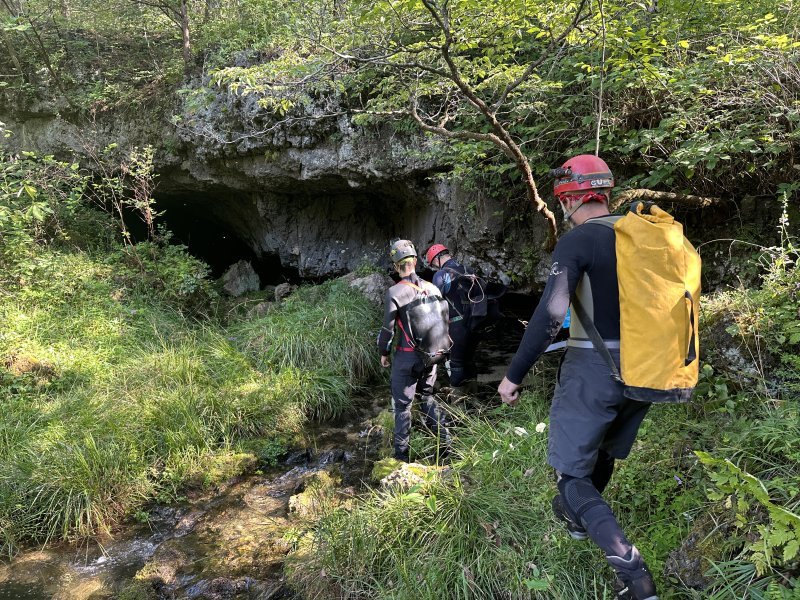
The pole retrieval team consolidated vehicles and departed Winona around 8:30. It was a ~20 minute drive to the parking area for the cave, which was filled to the max with vehicles after we had arrived. Fortunately, the summer temperatures had dropped a bit ahead of the next heat wave which made the short wetsuit hike over to the cave quite bearable. We reached the spring entrance at 9:30. Water flows out of the mouth of the cave for about a mile down Powder Mill Creek and feeds directly into the Current River.
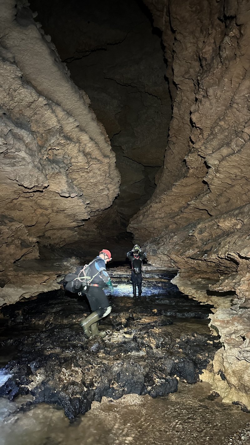
All 11 of us piled into the cave and began wading through the decorated borehole. We passed a few old beaver dens up on the right side of the stream bank. The passage averaged 30’ wide by 20’ high at first with mostly shallow wading. The further we went, the passage became even bigger and more highly decorated. The water was noticeably clear, even in some deeper undisturbed pools which had a nice blue color. Thanks to the steady flow of water out of the cave, there is no boot sucking mud on the floor, which is quite the contrast to the long slogs down the rivers in Carroll Cave.
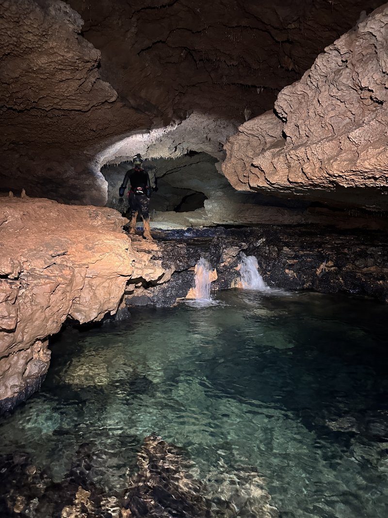
We continued further down the passage and the ceiling rose up to a 30’ tall canyon just after a bend to the left. The walls were decorated with the black/white/orange flowstone combinations that I have noticed to be characteristic of the Ozarks. The sounds of shallow water rushing through the black chert bedding on the floor could be heard just before we reached the first waterfall at 10am. The clear blue water at the base of the short waterfall was gorgeous.
We never did spot the “Hell Hole” which is an obscure low-airspace infeeder that opens up to an entirely different section of the cave. I didn’t go out of my way to seek it out, but it is still seems to be fairly elusive. Past the first waterfall, the cave eventually became highly decorated once again with some very tall multicolored flowstone formations coming down from the ceiling. Dan reported that in 2016 the formations were raining down water, but they were mostly dry on our visit. By 10:15, we reached the first water crawl. It is fairly short at around 300’ and I believe I still kept my upper body dry without putting on the top half of my wetsuit yet whereas most people were fully submerged in their wetsuits and floating through the passage.
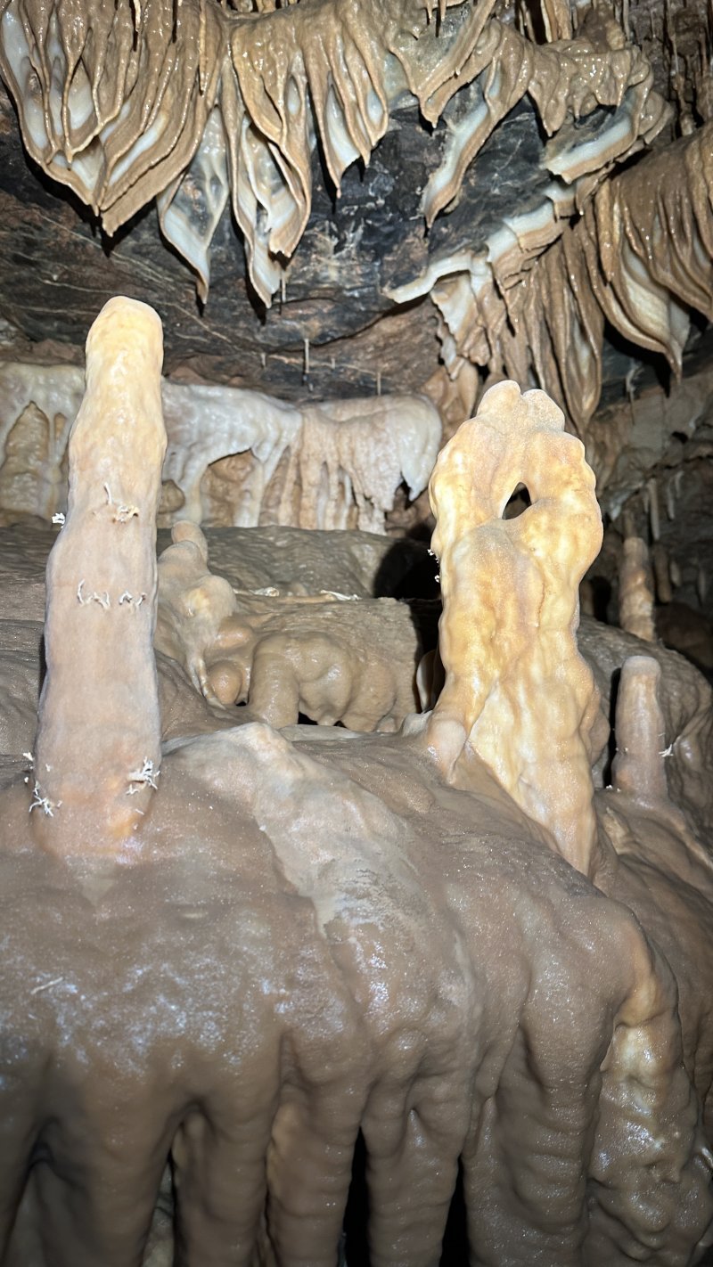
After the first water crawl, we traversed some mostly dry borehole and took our first break at 10:45. After a brief bit of route finding, we arrived at the second watercrawl. This one was a bit drier than the first, but still contained a few deeper pools. It was also around 300’ long like the first one, but with more chert beds and gravel. At the end of the crawl, you are rewarded with another slightly taller waterfall followed by a decorated area known as “The Cloisters”. This area contains many large flowstone formations eroded in interesting ways. Horizontal bands run all along the entirety of many of the already wavy formations creating a unique texture. We took a longer break in this area before continuing.
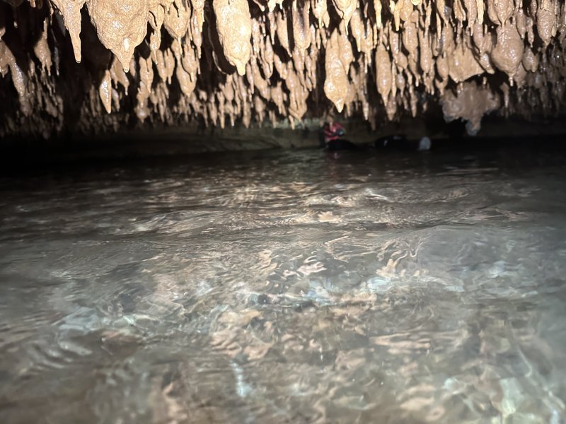
Initially from reading George’s notes, I was under the impression that the third water crawl didn’t start until a bit later, but it started almost immediately after The Cloisters. Upon reading the notes again, I see now that the full extent of the crawl is around 3000’ long (from ~6,500’ into the cave until 9,500’ into the cave), so about 10x the length of the previous water crawls! At one of the little domes in the beginning of the third water crawl where I could sit up, I finally decided to put on the rest of my wetsuit.
From here we were pretty much entirely submerged in the water for a long time. Floating along wasn’t too bad and the current was practically negligible. The ceiling varied from soda straws, to small curving draperies, to corndog looking formations. There were eventually a few ear dipper sections. One was particularly gnarly at around 3”. I was taking video of Rob going through it just as Dan arrived and directed everyone over to the right side where it was a bit easier. Cathleen was not amused. We continued ear dipping along in the inverted corndog forest until we reached the start of the K-survey (Right Fork).
The Right Fork is still 1000’ shy of the end of the third water crawl. The infeeder passage was surveyed during a drought year for around 1500’ until the passage lowered to 1’ tall with 7” of airspace. The survey was headed directly under Powder Mill Creek and trending toward the next major ridge. Back at Winona, Dan had asked if I would be interested in checking the lead and I tried to recruit a few people but I wasn’t met with much enthusiasm. While we were all discussing it at the intersection in the cave, Dennis Novicky agreed to join me. Dennis and I tied our packs to a natural anchor in the ceiling around 12:30pm and the rest of the group continued further into the cave.
Dennis and I started down the passage which was surprisingly comfortable at first. Eventually we reached the low airspace where the survey had ended and we took turns leading ahead. It was probably the longest sustained low airspace crawl I’ve ever done but fortunately the passage was very wide and not too tight. My head was sideways and one eye closed. As long as I avoided that subconscious fear of not being able to turn my head 180 degrees I was able to keep my cool. We reached a small dome area where we could both sit side by side before continuing ahead. I let Dennis take the lead on the final push. There was some hesitation at first and it just looked like it was doing more of the same, but as we rounded another corner I heard Dennis announce that he saw it was opening up!
The exploration consisted of some decorated passages and a mix of walking/crawling/stooping. We passed 2 20’-diameter breakdown collapse rooms on the right side that went up to around 20’ above the stream level but were definitively plugged at the top. Climbing back down through the breakdown and into the stream, the passage continued but ultimately terminated in a much smaller room. At the bottom of the terminal room, the stream disappeared below the ceiling and breakdown in a too tight passage. I explored a tight passage that trended back in the direction we came, and confirmed it just looped around a long wall of gravel and back into the passage we came from.
I found it a bit easier to traverse the low airspace the second time on my back with my face sucking the ceiling. All in all, it was probably about a 90-minute side quest. As I approached the intersection where our packs were tied off, I heard voices and found Jen and Krista. They were getting too cold after reaching the third waterfall and decided to exit together. I just happened to cross paths with them at the perfect time. Dennis was ready for a break, but we continued for the final 1000’ of the third water crawl so we could get out of the water first. We got some food and water in us around 2pm before continuing further into the cave.
The passage ahead was my favorite in the cave. It wasn’t enormous, but was pretty much entirely walking sized passage. The walls were chaotically scalloped into fragile appendages. Formations of every kind were plentiful. There was one particularly impressive display of helectites. Soda straws grew down at swaying angles. Some bacon draperies formed at the bottom side of a black block of chert in white and tan which made for an interesting contrast of colors.
At some point, we reached the fourth water crawl, which was another 1000’ of tedious floating. At the hustling pace to catch up with the group, I tried out different techniques to work different muscle groups such as floating on my back and using my heel to kick myself ahead. As we got further, we would find random items from the group stashed along the way as if they were leaving us little breadcrumbs to help us find our way back to them. As we approached the end of the fourth watercrawl, I could hear voices ahead. We had managed to catch up with the group. We took a bit of a rest, but others had already continued further into the cave.
After another 500’ of easy walking passage, I reached the climbing poles. At first there was a bit of confusion, as we thought there were supposed to be 3 (there were 2) and they were supposed to be left near a high lead (we didn’t see one). Others had already continued deeper into the cave, so I went ahead to try to catch up. As I went, I kept passing by people turning around and calling it quits. Eventually I reached Joe and Nathan who were the final two and went the farthest. They had reached the start of the 5th and final water crawl and decided to turn around.
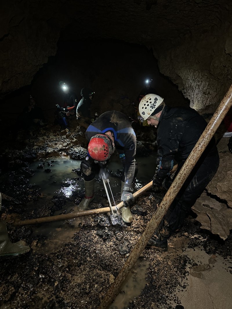
Back at the climbing poles, we realized the high lead was in fact right there. A slope along the back left wall went up and a very enticing lead took off 25’ up a steep mud slope. It looked as if I wouldn’t have much trouble climbing up the slope with the assistance of a rock hammer and carving out a few footholds along the way up. But the climbing pole had already served its purpose and the lead had been surveyed. The poles were surprisingly not that rusted and were still completely intact without any water having made its way inside. However, unlike the reports we received, they did *not* float.
It was 4:30pm when the hacksaw was taken out and Josh went to work cutting the poles. I was surprised at how quickly he managed to cut through them. The inside of the poles looked (and smelled) as fresh as they probably were when they were procured in the early 2000s. After they were cut in half, it was decided the best course of action would be to cut them in quarters so they would be small enough to fit in our packs. But first, we duct taped around the sharp edges to ensure they wouldn’t damage anything. I put two in my pack, Joe took 2 in his, Dan carried one, and 3 segments wound up in an old yellow drybag with webbing and rope that the original explorers also left in the cave. Cathleen and Nathan took turns hauling it, but Nathan pretty much muscled it all the way through the third watercrawl solo.
Given that it took the group about 7 hours to get to the back of the cave, I figured we’d be looking at an exit around 11 or possibly midnight. I spent a bit of extra time taking photos and videos of the really nice passages upstream of the third waterfall that I explored with Dennis without my phone accessible. The third watercrawl was an eternity. Fortunately, my pack floated which made the 3’ of metal pipe not add significant resistance as I pulled it behind me. But each time we had to crawl over a gravel bar or segment of dry passage, it was like a ball and chain weighing against me. Cathleen was channeling lots of externalized rage in order to power through it. All in all there was a fair bit of complaining, but overall spirits were still high. The only break we took was at the second waterfall just past the Cloisters around 7:30pm. The first wave managed to exit the cave around 9pm, ~5 hours from the back of the cave, a much faster pace than on our way in. Krista and Jen were there just inside the entrance waiting for us. They had been hanging outside for several hours but eventually came back into the cave around the time they expected we’d be arriving.
All the segments of the pole were successfully extracted, along with the old torn up drybag of webbing and yellow death rope. We exceeded our expectations of success with a great deal of effort. Looking more closely at the notes, I calculate a cumulative ~9200’ of water crawling between the 8 (roundtrip) water crawls. That’s 1.74 miles of water crawling! Oddly enough, my fingers seem to be sore from using them to pull myself forward on the floor while floating through the water crawls, that’s a new sensation. It was a roughly 5.5 mile round trip, plus an extra ~1 mile for Dennis and I checking the right fork.
We made it back to Winona and chowed down hard. Another unforgettable trip. Now the fun part will be going back and somehow managing to survey through that low airspace in the Right Fork. There is also one final unchecked lead a couple hundred feet before where the poles were stashed. Perhaps another day!
Click here to view my entire archive of trip reports & caving articles