Trip Report
Devil’s Icebox: Chert Bridges Survey Trip Report
Trip Date: Sep 23 2023An 8-hour Survey trip into one of Missouri’s longest caves located in a state park. The upstream trip requires a half mile paddle with four portages before reaching the walkable borehole passage.
Devil’s Icebox is currently listed as the 8th longest cave in Missouri and is undergoing a (partial) re-survey project led by Spike Crews. A survey in 1959-1960 produced a quality map, but some sections of the cave were surveyed and never added to the map, and some sections of the cave were still left unsurveyed. Spike is using the old data and building off of the original map.
The cave is located on Rock Bridge Memorial State Park near Columbia, Missouri. It can be approached by the general public via a wooden staircase down into the sinkhole/karst window. The water flows out of “Devil’s Icebox” and into “Connor’s Cave” which are both sheltered under the same dripline inside the karst window and are really the same cave. Connor’s Cave is a sacrificial cave open to exploration by the public and extends for maybe 200’ until reaching a siphon. The water resurges into some wet passage on the other side and exits the cave into a wide streambed. The stream continues for a few hundred feet before reaching the massive ~300’-long rockbridge/tunnel cave for which the state park is named.
Devil’s Icebox is only accessible to survey trips during September or October due to the bat population. The park provides canoes which must be transported to the trailhead, then carried a third of a mile uphill to the entrance. Our trip this year was nearly canceled due to the weather, but fortunately I got the clear from Dan Lamping at 5:30am before driving heading out that the trip was still on.
I arrived in the parking lot at 7:30am after the 2.5-hour drive from Kansas City. People slowly started to trickle in and we convened in the park office at 8am where Spike discussed the objectives for the day. There would be 4 teams working various areas of the cave. Myself, Kyle Mann, Nathan Curran, and Jen Sutherland would be continuing a survey of a lead off the “Chert Bridges” area which had been worked on in recent weeks by other teams. During my trip last year, we surveyed in the far reaches of the Left Fork, a major infeeder which according to Spike is now the source of most of the upstream water of the cave. The Chert Bridges area is located further upstream along the main passage past the Left Fork. This section of the cave is still very wet but carries less of the water.
The canoes were loaded onto the trailer and ready to go by 9am. Shortly after arriving at the trailhead, I went ahead and grabbed a canoe and started trekking uphill as fast as I could. The weight of the canoe starts to bruise your shoulders after a while so I just wanted to get it over with as quickly as possible. After one wrong turn, I arrived at the staircase heading down into the sink and waited for curious park visitors to clear the area before carefully navigating down. We were in the cave by 9:30am and began our half-mile paddle trip upstream.
The entrance passage was extra breezy, and the water level seemed a bit lower than it was last year. There were several spots where you had to fight to push the canoe forward over rocks in addition to the 4 portages. Paddling through the meandering stream canyon really is a unique experience and a lot of fun. We made it to the boat landing area at 10am and waited for everyone else to arrive. The rest of the journey into the cave would be on foot.
A couple other teams would also be targeting objectives near where we were headed so the majority of the group stayed together on the way in. We took one quick pitstop somewhere along or near “The Bypass” to check out some chocolate/vanilla draperies but otherwise kept a fairly steady pace. There were several waist-deep wading sections along the way, where it was often guesswork on which route through the water would avoid the deeper pools.
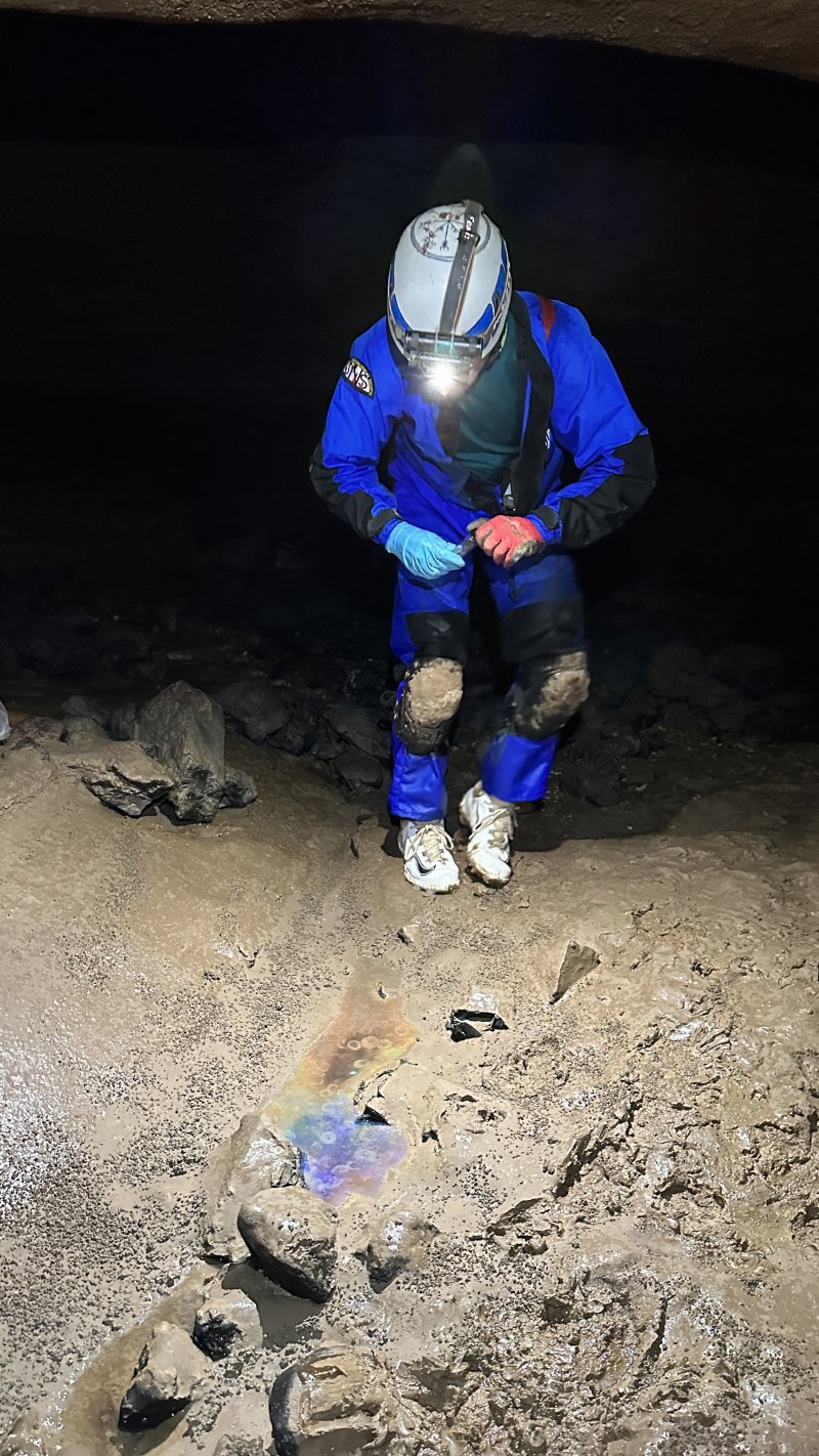
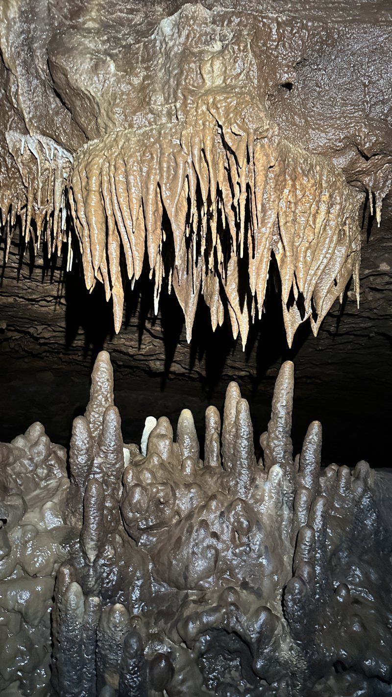
At 11:30, we reached a shallow pool perched up above the stream passage just before “Big Dome” where some type of oil was noted on a previous trip. Samples of this rainbow pool were taken to be analyzed to see what it might be. There were very nice formations along the left wall of the wading passage beyond, including a 30’ long chocolate ribbon with a white stripe running along the bottom arching over a wall of sparkling white and tan calcite taking various forms. By 12pm, we had reached the Chert Bridges area where we would start our survey.
Our lead had a stack of rocks and a handline up into it but was a fairly easy climb-up. There were two levels inside which had only been surveyed for a few stations by the last group. We started targeting the lower lead which was the RB-survey. Nathan Curran sketched, Jen Sutherland scouted ahead, Kyle Mann took frontsights, and I was setting stations and taking backsights. We accidentally resurveyed (oops) a few stations in a tight crawlway that Kohl Mitchell had already sketched. The passage from there continued in a very tight crawlway that looked grim. To the left, the narrow passage climbed up 10’ and continued in a more comfortable crawlway at the top. We surveyed up and through this crawlway which opened up into a dome complex. The upper lead at the beginning of the RB-survey that we did not do apparently continues to an overlook of this area that the original explorers rappelled down into before realizing the crawlway below connected in.
At the far side of the dome complex, a 20’ climb-up led to an obvious continuation. We could see the upper lead rise up beyond another ceiling shelf into what appeared to be large passage. I tried briefly to climb it, but thin mud coating on the walls didn’t provide as much grip as I would have liked, and the top of the climb was overhung by a collection of 100lb boulders that looked like they could be dislodged. Once Nathan caught up with his sketch around 2pm, he decided to go for the climb, and made it up without issue. He reported that there were footprints at the top. Kyle was getting chilly so I encouraged him to join me as I crawled back to the beginning of the RB-survey to retrieve the handline there so we could have Nathan rig it at the top of the climb.
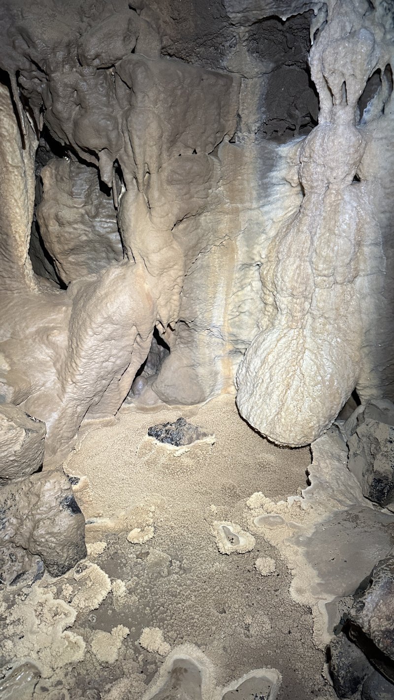
By 2:30pm, all of us had successfully made it up. At the top, there was a very nice formation area on the right. White flowstone along the wall met the lip of a fossil pool filled with spar crystal lily pads. We took a few shots to complete the survey of this room. All that was left was an upper level wet belly crawl lead near the far end of the room which I noticed had significant airflow. We took one survey shot into it and then Nathan went ahead and pushed it. He explored it for ~50’ before it became too tight and would require digging. He observed some bones and an infant mouse that was barely alive. Afterward, we made our way back down the climb to rejoin with the group at 3:30pm. Dan reported that they found another lead up around the corner which was too tight for anyone to fit through. Nathan was able to squeeze through and check it out briefly, and confirmed it was virgin passage. It would have to be surveyed at a later date, as we had to be out of the cave by 6pm due to the threat of the storms later that day.
We got out of the cave in time and headed back to the park office where the boats were washed and stowed away. I was relieved that I didn’t have to carry a canoe both ways this year. Afterwards a bunch of us went out for pizza. Around the time we were heading out, the storms were rolling in and looking ominous. Fortunately I avoided them along my drive back west to Kansas City. A shorter trip than usual, but still nice to get out at a reasonable time.
Click here to view my entire archive of trip reports & caving articles